Mount Mitchell is the highest peak in the eastern United States. It is part of the Black Mountain Range, which is a region of the larger Appalachian Mountains. Specifically, Mt. Mitchell is located in western North Carolina near the town of Burnsville.
 |
| MAP (click pictures to view larger) |
HISTORICAL BACKGROUND
Mt. Mitchell is 6,684 feet above sea level. It was named after Elisha Mitchell who measured the mountain's height in 1835. Historically, Mt. Mitchell was primarily covered in red spruce and fraser firs, which are two evergreen species. Chestnut, hickory, and oak trees also dominated. The area was inhabited by Cherokee Indians, who used it as hunting grounds.
(map source: resortbay.com)
HUMAN IMPACTS
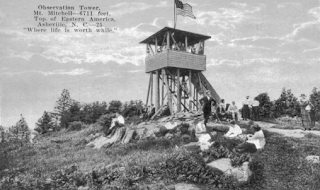
Here on the right is a picture of a postcard from 1920 (source: ncpedia.org) that shows on observation tower on the summit. Industrial logging and the chestnut blight led to the destruction of millions of acres of forest in the entire Appalachian mountains.
In the 1950s, the non-native Balsam Woolly Adelgids from Central Europe were introduced to the North Carolina. Even though this species was accidentally brought over to the United States, it had a tremendous impact on Mount Mitchell. Balsam Woolly adelgids killed off most of the native firs. They cause severe gouting, prevent the normal growth of needles and buds, cause it to produce abnormal wood cells, and harms its ability to take up water and nutrients. In particular, these small insects infest and kill off fraser and balsam firs. Fraser firs are also known as Christmas trees to us. On the left is a picture of an infested tree bark.

Acid rain has been the biggest threat to Mt. Mitchell. Acid rain is most prevalent downwind from coal-burning electric power plants. Air pollution from power plants and industries from surrounding states such as Tennessee and Ohio are carried by the winds
into Mt. Mitchell (and the Appalachian Mountains in general). Acid rain forms as a result of nitrogen oxide emissions reacting with water vapor in the atmosphere. When soil is soaked with acid rain, important nutrients are dissolved and aluminum released from the soil makes it hard for trees to take up water. Trees in high elevations are the most affected because they are the most exposed to acid clouds and fog, which are highly acidic. These clouds take away necessary nutrients from leaves and needles of trees.
THE FUTURE OF MOUNT MITCHELL
THE FUTURE OF MOUNT MITCHELL
Acid deposition contributes significantly to forest decline. Acid fog envelopes trees and because nitrogen oxide emissions are harder to regulate, this ecosystem will continue to suffer from pollution in the form of acid rain. Fortunately, because the mountain is protected by Mount Mitchell State Park, there has not and will not be any direct human impact, like industrial logging for instance.
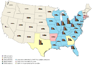
To the left is a diagram from the Environmental
Protection Agency's website that shows nitrogen oxygen emissions from the years
1990-2009. In the span of 19 years, there has been a significant downward trend
of NOx emissions. As a result, I think the future prospects of Mt. Mitchell
look good. Mt. Mitchell State Park was established in 1915, so the area has not
been open to logging or similar direct threats since then. In 2005, The Clean
Air Interstate Rule (CAIR) was issued by the EPA to "[provide] states with
a solution to the problem of power plant pollution that drifts from one
state to another." (epa.gov) With CAIR, the various sustainable
practices power plants have adopted, and states meeting air quality standards,
Mt. Mitchell will remain in good condition.
I do not think it will be much of an effort to maintain the relatively positive state of Mt. Mitchell. State air quality standards and legislation have made significant efforts to reduce pollution. Emissions, or how much people drive, cannot be controlled while industry practices can. If we continue to reduce the amount of harmful substances we put into the air, we can contribute to maintaining forests everywhere. By conserving energy at home whenever possible, we contribute to a reduction of chemicals power plants emit and by carpooling, using public transportation, or walking, we can also reduce the amount of emissions we put into the air. Doing so will also hopefully reduce the acidity of rain that falls on Mt. Mitchell, which is the primary threat to the area.
Sources used:
http://www.epa.gov/acidrain/effects/forests.html
http://www.grandfather.com/conservation_interpretation/acid_rain.php
http://nynjctbotany.org/polltnsc.html
http://www.anapsid.org/aboutmk/pollute1.html
http://main.nc.us/BMCP/mitchell.html
http://ncpedia.org/mount-mitchell
http://www.na.fs.fed.us/pubs/fidls/bwa.pdf
http://www.epa.gov/air/emissions/index.htm
http://environment.nationalgeographic.com/environment/global-warming/acid-rain-overview/


No comments:
Post a Comment